


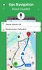

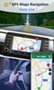
GPS Satellite View: Live Maps offers a comprehensive solution for navigation and mapping needs. Designed for precision and ease, this app enables you to navigate efficiently with real-time GPS voice guidance and live traffic updates. It provides detailed street views, satellite imagery, and route planning to help you find the shortest or most suitable path to your destination. Whether you are exploring urban areas or venturing into remote locations, GPS Satellite View: Live Maps ensures accurate and seamless navigation tailored to your needs.
Real-Time Traffic and Navigation Features
The app offers real-time traffic alerts to guide your route choices effectively. With its turn-by-turn navigation, you can effortlessly plan trips while avoiding congested areas. The route finder feature streamlines your travel by identifying the shortest and quickest paths, saving you time and enhancing efficiency. For those keen to explore, GPS Satellite View: Live Maps also provides options to discover nearby locations, such as bus stops, subway routes, hotels, and hospitals, making it ideal for travel and daily commutes.
Innovative Satellite and Location Services
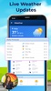
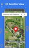
With satellite imagery and street views, GPS Satellite View: Live Maps allows you to explore destinations virtually before visiting. Additional tools include weather updates through a live forecast feature and the ability to save GPS locations for reference. Its area measurement tool further supports trip planning and practical navigation, ensuring you are always prepared for your journey.
GPS Satellite View: Live Maps combines advanced GPS technology with user-friendly features to provide a dependable navigation experience. Whether for personal travel, daily commuting, or exploring new places, this app is a reliable companion for navigating the world.
Requirements (Latest version)
- Android 7.0 or higher required
Comments
There are no opinions about GPS Satellite View: Live Maps yet. Be the first! Comment